Web catalog
Most read
Most read last 7 days
Most Discussed
Top rated
Statistics
- Total registered users: 9886
- Total articles: 23656
- Total comments: 2087
- Last entry: Kebo presenting evidence that Izetbegovic brought mujahideen to Bosnia
- Last update: 11.01.2019. 23:44
Historical and Geographical Outline
Written 27.11.2009. 12:43
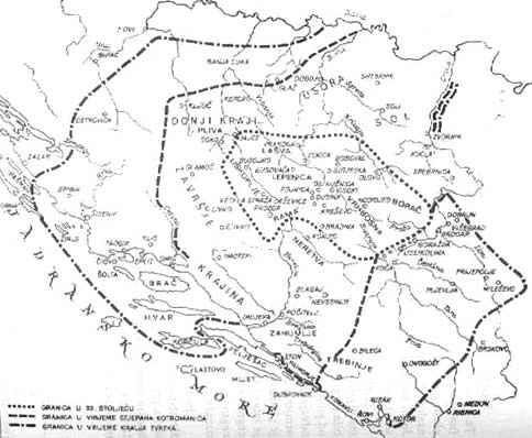
 Medieval Bosnia shared many characteristics with other South-Slavic states of the period. That political domain (not a state!) was established as a military commonwealth and functioned as a patriarchal family. Historian Nada Klaic makes a connection between the creation of the Bosnian political domain and the dominion of the Avars where the term "Ban" (used by Croatian and Bosnian leaders) originated. The Bosnian lands, having been politically organized along the same lines as the other South Slav countries, from the outset enjoyed independence which was to last for another 400 years.
The core of the old Bosnian state (see map 19) was geographically nested within regions that the Bosnian core gradually annexed. The river Drina separates the Bosnian core from Serbia, and the Serbian king Nemanja\'s state never crossed the river, but rather directed its expansionary efforts at the Zahumlje region (maps 4 and 5). Eventually, after many changes of fortune, Zahumlje was incorporated into the Bosnian state, and on the eve of the Ottoman occupation, that was a region under the control of Herceg (Duke) Stjepan Vukcic. This region eventually assumed the name of Hercegovina, but the name Dalmatia is evident on most older maps. Hercegovina was a subordinated and a less common term. On some maps, this region is termed Turkish Dalmatia.
Regions north, west and south of the historical core naturally gravitated towards Croatia, and the medieval histories of Croatia and Bosnia are intertwined. Bosnia expanded territorially onto historical Croat regions (compare map 19 with map 11),
and King Tvrtko (1353-1391) ruled over regions east of Drina. After Tvrtko\'s passing, Bosnian aristocrats each ruled over specific regions, including historical Croatian regions (map 20).
By the end of the 16th Century, the Ottomans formed one Pashaluk (a military territorial
unit), encompassing the Bosnian kingdom and other regions won from Croatia (Sanjaks/provinces Pakrac, Bihac, Klis and Hercegovina). The Croatian historical regions on the western part of the Pashaluk were called "Turkish Croatia" on many older maps. Sanjaks Pozega and Srijem were outside the Bosnian Pashaluk, and these were collectively called Turkish Slavonia. Due to turbulent historical circumstances, a large part of Croatia\'s historical territories is now a part of Bosnia and Hercegovina. Old maps clearly show that the border between the Ottoman Bosnia and Serbia is the river Drina.


 Kontaktirajte nas
No comments